The immersive hydroinformatics framework developed in this study integrates extended reality (XR) technologies using the Unity engine and Mapbox Maps SDK to create a detailed 3D representation of the continental United States. It incorporates real-time data from USGS Water Services and NWS weather forecast APIs, providing an interactive environment that enhances user understanding of hydrological phenomena through dynamic visualization. The application, designed for both VR devices and web browsers, uses WebXR to ensure compatibility and accessibility, supporting a broad audience including researchers and educators. Future development will focus on collaborative interactions and mixed reality (MR) options to expand the framework's applicability. Additionally, alternative map providers may be explored to improve visualization quality. The project aims to enhance user engagement and understanding of hydrological processes through immersive, dynamic visualizations.
Related Articles
- Herath Mudiyanselage, U., Gonzalez, E. L., Sermet, Y., & Demir, I. (2024). An Immersive Hydroinformatics Framework with Extended Reality for Enhanced Visualization and Simulation of Hydrologic Data.
DOI: https://doi.org/10.31223/X54X4G
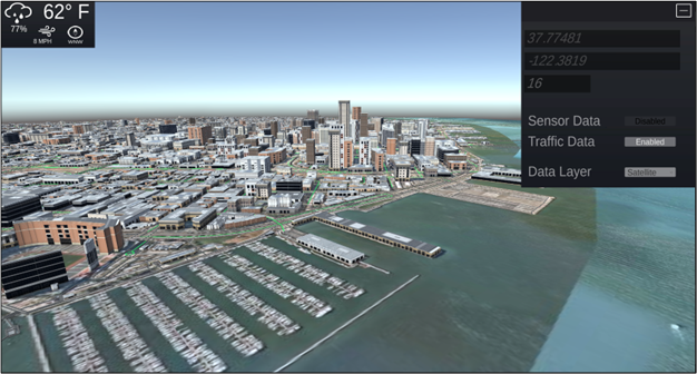
Mapbox generated location along with input and information panel.
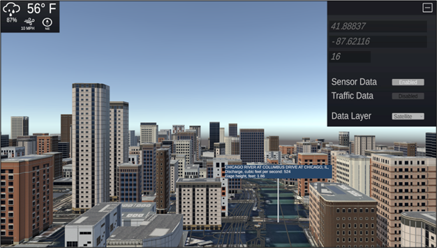
Weather information from the USGS Weather API being displayed in the user view along with stream conditions from the USGS Discharge API.